GloboLakes is a five year research programme that will investigate the state of lakes and their response to climatic and other environmental drivers of change at a global scale through the realisation of a near-real time satellite based observatory with archive data processing to produce a 20-year time series, of observed ecological parameters and lake temperature supported by linked auxiliary data on catchment land-use and meteorological forcing.
The world’s freshwater ecosystems, and the biodiversity they support, are vital components of the global biosphere, yet remain fragile and vulnerable to anthropogenic disturbance and climate change. There is increasing recognition that lakes play an important role in global biogeochemical cycling and ecosystem services[1]. However, our understanding of how lakes respond to environmental change at a global scale, and how this impacts on their status and function, is hampered by limited information on their chemical, physical and ecological condition[2]. There are estimated to be some 304 million lakes globally, of which over 17,000 are greater than 10km2 in surface area[3]. These sheer numbers have militated against the systematic study of lakes[4].
While lake responses to eutrophication are well understood, the potentially confounding interactions between climate forcing, eutrophication and other hydrological pressures have yet to be fully established. There is evidence to suggest that climate change might intensify the effects of nutrient enrichment leading to increases in the incidence, magnitude and geographic spread of potentially harmful cyanobacterial blooms[5]. Increasing temperature and higher intensity rainfall events may also lead to changes in the terrigenous inputs of dissolved organic carbon (DOC) and sediment, which will also have far reaching effects on ecosystem structure and function. Several case-studies have shown that water quality parameters, such as lake surface temperature[6] and the timing of spring phytoplankton blooms[7] show coherent responses to synoptic-scale meteorological forcing[8]. The results from these studies imply that lakes are capable of spatially and temporally integrating and amplifying meteorological signals and thus may act as useful sentinels and regulators of climate change[2]. However, increasing the spatial scale of comparison from regional[9] to continental[7] is highly problematic through field based observations alone, resulting in inconsistencies in data quality and comparability of variables, and limited spatial and temporal resolution. This has hindered the ability to resolve subtle systematic changes in phenology, magnitude and coherence of events. Untangling the climatic signal from other drivers of change, such as changing land and water resource management and internal ecosystem dynamics, is a challenge requiring multi-scale observations of a suite of functionally relevant and reliable indicators of lake ecosystem condition and transdisciplinary collaboration.
The potential of remote sensing as a source of limnological information over large geographical areas has yet to be fully realised, due in part to (i) insufficient data availability (spatial and spectral resolution of sensors); (ii) the lack of robust inversion algorithms that relate observed radiances to lake water properties (consistuent concentrations, temperature) consistently across consecutive/multiple satellite missions; (iii) the logistical challenges of robust large-scale processing of near real time imagery and full-archive reprocessing.
The recently developed semi analytical algorithms for the retrieval of chlorophyll a (Chl a) and C-phycocyanin (C-PC: cyanobacteria-specific pigment) have shown promise for regional-scale monitoring[10] of lake ecosystem dynamics. The use of these algorithms with the MERIS and MODIS sensors provides a way forward for interpreting and monitoring of lake ecosystem condition and change[11,12]. Moreover, PML now provide the capability of processing full resolution (300 m) MERIS and the forthcoming Sentinel 2 and 3 data in near-real time, as well as large volumes of archived data. The development of operational algorithms for the remote retrieval of biogeochemical parameters (Chl a; C-PC; total suspended matter; diffuse attenuation coefficient) and processes (primary production), and their implementation in automated processing chains, will provide a breakthrough in systematic observation of lakes at a global scale. MERIS data will provide a time series data set to 2002, which will be extended to 1997 with SeaWifs data (limited biogeochemical parameters). Lake surface water temperature (LSWT) closely reflects the physical dynamics of lakes (stratification and mixing) in response to meteorological forcing. LSWT influences ecosystem dynamics directly (through differential population responses) and indirectly (via dynamic effects on nutrient distribution). New techniques applied to ATSR sensors have generated accurate and consistent LSWT time series for >250 large lakes globally[15] from 1995 to 2009, with potential to expand this capability to finer spatial resolution, longer time series, and a larger set of target lakes.
The application of ecological indicators previously developed for marine waters[13,14] (e.g. timing of the spring bloom, duration, magnitude), plus cyanobacteria abundance, offers great potential understanding and monitoring lakes, particularly in conjunction with knowledge of the evolution of lake temperature in response to meteorological forcing. There is now the opportunity to synthesize and exploit consistent ecological and physical observations of lakes over two decades for a large number of lakes (>1000) globally. The ability to monitor a large numbers of lakes consistently at high frequency and globally will facilitate a paradigm shift in our understanding of how lakes respond to environmental change at different scales, and how this impacts on their status and function[16,17].
- Development of robust algorithms for the remote sensing of biogeochemical parameters, primary production and LSWT for lakes at regional to global scales. Algorithms to include quantified uncertainty estimates.
- Operationalisation of these algorithms in a satellite-based Global Lake Observatory.
- Compilation of integrated spatio-temporal information on ecosystem condition and function for global network of lakes and their catchments.
- Models forecasting the trajectory of lake responses, including impacts on ecosystem services, to climate and land use change on lakes across different climate zones.
- An assessment of the sensitivity and coherence of lake response to environmental change at a global scale.
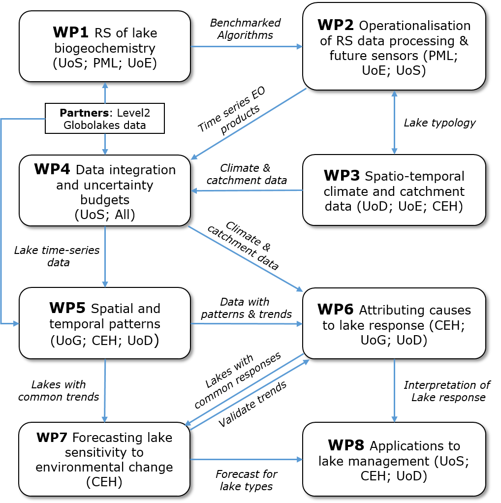
The GloboLakes project brings together key groups with a diverse range of expertise and capabilities (earth observation, lake ecology, high resolution automatic data acquisition, statistical modelling) that are needed to undertake the proposed research. The proposal builds a science infrastructure, whose participants need to work in a closely integrated manner to ensure a tight linkage between method development and the desired science outcomes.
Science engagement with key international groups (including: CSIRO, DLR, Environment Canada, GEO, Hungarian Academy of Sciences- BLRI; INTA, ISPRA, JRC, NIGLAS, and the Universities of Cape Town, City College of New York, Creighton, Milan, Tartu, Wisconsin), the Global Lakes Ecology Observatory Network and NEODAAS, and impact with environment and health.
[1] Tranvik et al, 2009. Limnol. & Oceanogr. [2] Williamson et al., 2009. Limnol. & Oceanogr. [3] Downing et al., 2006. Limnol. & Oceanogr. [4] Wantzen et al., 2008. Hydrobiol. [5] Pearl & Huisman, 2008. Science. [6] Schneider et al., 2009. Geophys. Res. Letters. [7] Blenckner et al., 2007. Glob. Change Biol. [8] Livingstone & Padisak, 2007. [9] George et al., 2000. Freshwater Biol.[10] Hunter et al., 2010. Remote Sens Environ. [11] Gons et al., 2008 Remote Sens. Environ.; [12] Matthews et al., 2010. Remote Sens Environ. [13] Platt et al., 2009. Geophys. Res. Letters; [14] Platt et al., 2008. Remote Sens. Environ. [15] MacCallum & Merchant, 2011, Can J Rem Sens. [16] Wantzen et al., 2008. Hydrobiol., 613, 1-4; [17] Williamson et al., 2009. Limnol. & Oceanogr., 54, 2273-2282